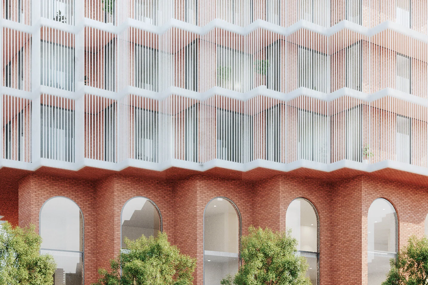
Davenport Diamond Guideway Public Realm
The davenport diamond guideway and greenway is envisioned to be a recreational and cultural destination that responds to and compliments its surrounding context and the character of its community.
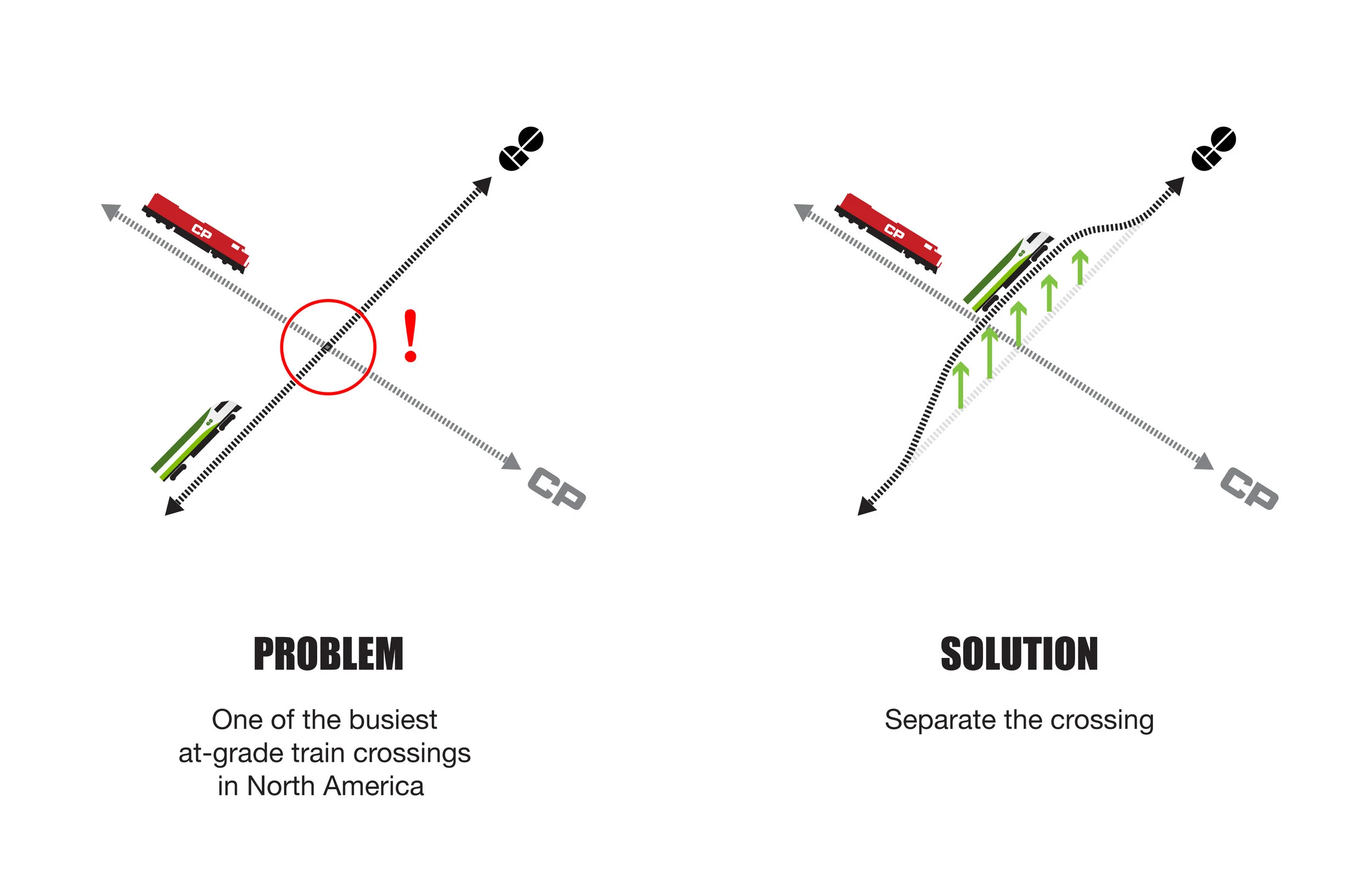
The Davenport Community Rail Overpass will replace the ‘Davenport Diamond’, one of the busiest train crossings in North America where CP Rail freight trains intersect with GO commuter trains on the Barrie corridor. The proposed elevated railway line running between Bloor Street West and Davenport Road opened up new land below the overpass, whose design invents a unique multi-modal space for the use and enjoyment of a local and regional public in Toronto. It anticipates and protects a public realm, while establishing connections to the Railpath, Green Line, Bloor GO Station, and Lansdowne TTC Station, and plans for the private and public adjacencies of future development.
The multi-modal space of the Greenway responds to different zones of influence along the corridor so that the specific amenities provided correspond to the character and programs of the adjacent neighbourhoods.
The design of the overpass, the Davenport Diamond Guideway, frames a newly created public space and linear park, the Greenway, which connects local streets and parks previously severed by the railway and provides a range of all-season amenities to cyclists and pedestrians. At the scale of the city, the Greenway provides an important link in Toronto’s pedestrian and cycling network. On a neighbourhood scale, it creates new east-west connections at Paton Road, Sarnia Avenue, and Antler Street/Lappin Avenue, and strengthens existing east-west connections at Wallace Avenue (and the adjacent public square) and Dupont Street. It also creates connections and increased accessibility to four city parks—Erwin Krickhahn Park, Campbell Avenue Park, Davenport Village Park, and Earlscourt Park (via a new pedestrian bridge at Davenport Avenue).

Dupont Crossing
The architecture, urban design, and artworks, among them a series of murals by Alex McLeod on the cladding of the Guideway, each contribute to garnering public attention and promoting the Guideway and Greenway as a public destination. The overall effect of the design is to physically and visually lighten the space surrounding the Guideway bridge and create a lush and vibrant Greenway below that accommodates activities for both a local community and a regional one.
At the Dupont connection, with the elevation of the railway corridor, the existing rail bridge over Dupont Street is transformed into a large-scale cycling and pedestrian bridge in order to maintain north-south accessibility. The bridge responds to the nearby Perth/Dupont branch of the Toronto Public Library and incorporates a quieter space for sitting and reading, as well as an observation deck and lookout across the urban environment surrounding Dupont Street. Access to the Greenway from street-level below is visible, well-lit, and designed to minimize conflicts between cyclists, pedestrians and other users of the public pathway.

Walks & Gardens
The interval of the corridor along the more residential areas adopts a quieter character. The seating infrastructure lines the plantings and is one-sided to discourage larger groups.
The material palette of the project is derived from the environment of railway tracks, incorporating steel, wood, gravel, and greenery that respond to the genius loci of the site. Inspired by a self-seeded environment, the design works to maximize greenery and populates the corridor with native plants that will generate an active and pollinating landscape.
The ground-level granular is binded to create a permeable membrane for water management on the site. The edges of the corridor surface and column bases, planting beds, and benches adopt a cove shape that creates a clear graphic pattern on the landscape, while protecting landscape plantings and better facilitating debris removal, cleaning, and maintenance. The use of graffiti resistant surfaces, durable materials, fixed furniture, and zero maintenance planting all endeavor to minimize the operating costs of the project. The curvature also references a motif of transit graphics, whose rounded edges are often associated with speed and unobstructed movement.


The project turns to next generation integrated engineering to allow for the lightest possible bridge structure and an extended “skylight” separating the tracks that lets in natural light for the native landscape plantings below. The minimal character of the round columns lessen obstructions along the corridor and the thinning of the Guideway platform at its edges refines and lightens its appearance. The columns are lit with continuous LED strip lights to illuminate and enliven the space at night and light-themed artworks animate and demarcate each of the east-west crossings, maintaining a safe and delightful environment with minimal light pollution.
Campbell Ave Park
Campbell Avenue Park extends into the Greenway, increasing accessibility for both public amenity spaces and allowing them to influence one another. The introduction of play areas with moguls, benches, swings, and a dog park compliments the programming of the adjacent park, which includes a basketball court, hockey rink, soccer fields, and playground. Along the edge where the park meets the shelter of the Guideway, an existing row of mature Siberian Elms is protected and preserved, while new terraced seating reinforces this threshold by offering opportunities for visual communication across the two public spaces.

Sarnia
Site amenities and variations of seating design use wood as a primary material and generate their form from the diamond geometry of the rail crossing. Along the corridor, seating areas are grouped and aggregated to create multiple opportunities for sitting, reclining, and play. These areas border the multi-use trail, designed to encourage safe interaction between cyclists, pedestrians, and drivers. Wayfinding and signage, as well as infrastructure for community information, are integral components to the overall design strategy.

Wallace
At the Wallace connection, the Greenway serves as an overflow space for surrounding offices and reflects a need for adult leisure amenities, designing opportunities for meeting and congregation. The Greenway and the potential for a future Wallace Square will offer a catalyst for the emerging urban character and cultural corridor along Wallace Avenue, creating new public spaces, both beside and below the Guideway, to enable community-building and social engagement year-round. As with all east-west connections, the design of the architecture, artworks, and lighting is integrated to create active and safe public spaces.

Client: Metrolinx
Location: Toronto ON
Design Completion: 2018
Project team: Hatch (prime consultant, engineering), gh3 (architecture, urban design, landscape architecture)
Consultants: Urban Strategies (planning), Lightemotion (lighting), Applied Wayfinding, Brad Golden (public art consultant), Workshop Architecture (community consultation), AW Hooker (cost)
gh3* Team: Pat Hanson, Raymond Chow, Joel Di Giacomo, Byron White, Jan Adegeest, Jeffrey Deng, John Natanek, Kaining Peng, Mani Tabrizi, Mark Kim